The Caspian Sea (Russian: Каспи́йское мо́ре, tr. Kaspiyskoye more; IPA: [kɐˈspʲijskəjə ˈmorʲə], Azerbaijani: Xəzər dənizi, Kazakh: Каспий теңізі Kaspiy teñizi, Persian: Daryā-e Xazar , Daryā-e Kāspiyan, Turkmen: Hazar deňizi) is the largest enclosed inland body of water on Earth by area, variously classed as the world’s largest lake or a full-fledged sea. The sea has a surface area of 371,000 km2 (143,200 sq mi) (not including Garabogazköl Aylagy) and a volume of 78,200 km3 (18,800 cu mi). It is in an endorheic basin (it has no outflows) and located between Europe and Asia. It is bounded to the northeast by Kazakhstan, to the northwest by Russia, to the west by Azerbaijan, to the south by Iran, and to the southeast by Turkmenistan. The Caspian Sea lies to the east of the Caucasus Mountains and to the west of the vast steppe of Central Asia. Its northern part, the Caspian Depression, is one of the lowest points on Earth.
The ancient inhabitants of its coast perceived the Caspian Sea as an ocean, probably because of its saltiness and large size. It has a salinity of approximately 1.2% (12 g/l), about a third of the salinity of most seawater.

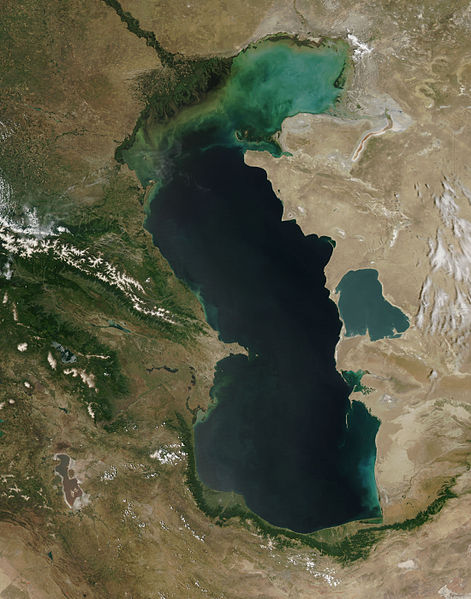
The Caspian Sea as captured by the MODIS on the orbiting Terra satellite, June 2003
Etymology
The word Caspian is derived from the name of the Caspi (Aramaic: Kspy, Greek: Kaspioi), ancient people who lived to the south-west of the sea in Transcaucasia. Strabo wrote that “to the country of the Albanians belongs also the territory called Caspiane, which was named after the Caspian tribe, as was also the sea; but the tribe has now disappeared”. Moreover, the Caspian Gates, which is the name of a region in Tehran province of Iran, possibly indicates that they migrated to the south of the sea. The Iranian city Qazvin shares the root of its name with that of the sea. In fact, the traditional Arabic name for the sea itself is Bahr al-Qazwin (Sea of Qazvin).
In classical antiquity among Greeks and Persians it was called the Hyrcanian Ocean. In Persian antiquity, as well as in modern Iran, it is known as the Mazandaran Sea . In Iran, it is also referred to as Daryā-i Xazar sometimes. Among Indians it was called Kashyap Sagar. In Turkic-speaking countries it is known as the Khazar Sea. Old Russian sources call it the Khvalyn or Khvalis Sea (Хвалынское море / Хвалисское море) after the name of Khwarezmia. Ancient Arabic sources refer to it as Baḥr Gīlān meaning “the Gilan Sea”.
Turkic languages use a consistent nomenclature that is different from the Indo-European languages above. For instance, in Turkmen, the name is Hazar deňizi, in Azeri, it is Xəzər dənizi, and in modern Turkish, it is Hazar denizi. In all these cases, the second word simply means “sea”, and the first word refers to the historical Khazars who had a large empire based to the north of the Caspian Sea between the 7th and 10th centuries.
Physical characteristics
Formation
The Caspian Sea, like the Aral Sea, Black Sea, and Lake Urmia, is a remnant of the ancient Paratethys Sea. It became landlocked about 5.5 million years ago due to tectonic uplift and a fall in sea level. During warm and dry climatic periods, the landlocked sea almost dried up, depositing evaporitic sediments like halite that were covered by wind-blown deposits and were sealed off as an evaporite sink when cool, wet climates refilled the basin. Due to the current inflow of fresh water, the Caspian Sea is a freshwater lake in its northern portions. It is more saline on the Iranian shore, where the catchment basin contributes little flow. Currently, the mean salinity of the Caspian is one third that of Earth’s oceans. The Garabogazköl embayment, which dried up when water flow from the main body of the Caspian was blocked in the 1980s but has since been restored, routinely exceeds oceanic salinity by a factor of 10.
Geography
The Caspian Sea is the largest inland body of water in the world and accounts for 40 to 44% of the total lacustrine waters of the world. The coastlines of the Caspian are shared by Azerbaijan, Iran, Kazakhstan, Russia, and Turkmenistan. The Caspian is divided into three distinct physical regions: the Northern, Middle, and Southern Caspian. The Northern–Middle boundary is the Mangyshlak Threshold, which runs through Chechen Island and Cape Tiub-Karagan. The Middle–Southern boundary is the Apsheron Threshold, a sill of tectonic origin between the Eurasian continent and an oceanic remnant, that runs through Zhiloi Island and Cape Kuuli. The Garabogazköl Bay is the saline eastern inlet of the Caspian, which is part of Turkmenistan and at times has been a lake in its own right due to the isthmus that cuts it off from the Caspian.
Differences between the three regions are dramatic. The Northern Caspian only includes the Caspian shelf, and is very shallow; it accounts for less than 1% of the total water volume with an average depth of only 5–6 metres (16–20 ft). The sea noticeably drops off towards the Middle Caspian, where the average depth is 190 metres (620 ft). The Southern Caspian is the deepest, with oceanic depths of over 1,000 metres (3,300 ft). The Middle and Southern Caspian account for 33% and 66% of the total water volume, respectively. The northern portion of the Caspian Sea typically freezes in the winter, and in the coldest winters ice forms in the south as well.
Over 130 rivers provide inflow to the Caspian, with the Volga River being the largest. A second affluent, the Ural River, flows in from the north, and the Kura River flows into the sea from the west. In the past, the Amu Darya (Oxus) of Central Asia in the east often changed course to empty into the Caspian through a now-desiccated riverbed called the Uzboy River, as did the Syr Darya farther north. The Caspian also has several small islands; they are primarily located in the north and have a collective land area of roughly 2,000 km2 (770 sq mi). Adjacent to the North Caspian is the Caspian Depression, a low-lying region 27 metres (89 ft) below sea level. The Central Asian steppes stretch across the northeast coast, while the Caucasus mountains hug the western shore. The biomes to both the north and east are characterized by cold, continental deserts. Conversely, the climate to the southwest and south are generally warm with uneven elevation due to a mix of highlands and mountain ranges; the drastic changes in climate alongside the Caspian have led to a great deal of biodiversity in the region.
The Caspian Sea has numerous islands throughout, all of them near the coasts; none in the deeper parts of the sea. Ogurja Ada is the largest island. The island is 37 km (23 mi) long, with gazelles roaming freely on it. In the North Caspian, the majority of the islands are small and uninhabited, like the Tyuleniy Archipelago, an Important Bird Area (IBA), although some of them have human settlements.

Map of the Caspian Sea, yellow shading indicates Caspian drainage basin. (Since this map was drawn, the adjacent Aral Sea has greatly decreased in size)
Hydrology
The Caspian has characteristics common to both seas and lakes. It is often listed as the world’s largest lake, although it is not a freshwater lake. It contains about 3.5 times more water, by volume, than all five of North America’s Great Lakes combined. The Caspian was once part of the Tethys Ocean, but became landlocked about 5.5 million years ago due to plate tectonics. The Volga River (about 80% of the inflow) and the Ural River discharge into the Caspian Sea, but it has no natural outflow other than by evaporation. Thus the Caspian ecosystem is a closed basin, with its own sea level history that is independent of the eustatic level of the world’s oceans. The level of the Caspian has fallen and risen, often rapidly, many times over the centuries. Some Russian historians claim that a medieval rising of the Caspian, perhaps caused by the Amu Darya changing its inflow to the Caspian from the 13th century to the 16th century, caused the coastal towns of Khazaria, such as Atil, to flood. In 2004, the water level was 28 m (92 ft) below sea level.
Over the centuries, Caspian Sea levels have changed in synchrony with the estimated discharge of the Volga, which in turn depends on rainfall levels in its vast catchment basin. Precipitation is related to variations in the amount of North Atlantic depressions that reach the interior, and they in turn are affected by cycles of the North Atlantic Oscillation. Thus levels in the Caspian Sea relate to atmospheric conditions in the North Atlantic thousands of miles to the northwest.
The last short-term sea-level cycle started with a sea-level fall of 3 m (9.84 ft) from 1929 to 1977, followed by a rise of 3 m (9.84 ft) from 1977 until 1995. Since then smaller oscillations have taken place.

Caspian Sea near Aktau, Mangistau region, Kazakhstan.
Environmental degradation
The Volga River, the largest in Europe, drains 20% of the European land area and is the source of 80% of the Caspian’s inflow. Its lower reaches are heavily developed with numerous unregulated releases of chemical and biological pollutants. Although existing data are sparse and of questionable quality, there is ample evidence to suggest that the Volga is one of the principal sources of transboundary contaminants into the Caspian. The magnitude of fossil fuel extraction and transport activity constitute risks to water quality. Underwater oil and gas pipelines have been constructed or proposed, increasing potential environmental threats.
Vulf, Azerbaijan has been affected by ecological damage because of the petrochemical industry. This has significantly decreased species of marine birds in the area.
Nature
Fauna
Sturgeons, including the beluga sturgeon, the largest freshwater fish in the world, inhabit the Caspian Sea in great numbers and yield roe (eggs) that are processed into caviar. Overfishing has depleted a number of the historic fisheries including the economic exhaustion of the tuna fishery. In recent years overfishing has threatened the sturgeon population to the point that environmentalists advocate banning sturgeon fishing completely until the population recovers. However, the high price of sturgeon caviar allows fisherman to afford bribes to ensure the authorities look the other way, making regulations in many locations ineffective. Caviar harvesting further endangers the fish stocks, since it targets reproductive females.
Reptiles native to the sea include spur-thighed tortoise (Testudo graeca buxtoni) and Horsfield’s tortoise. Although Caspian turtles (Mauremys caspica) distribute in nearby areas, this species is completely adapted for freshwaters.
The zebra mussel and the common carp are native to the Caspian and Black Seas, but have become invasive species elsewhere, when introduced.
The area has given its name to several species, including the Caspian gull and the Caspian tern. The Caspian seal (Pusa caspica) is the only aquatic mammal and is endemic to the Caspian Sea, being one of very few seal species that live in inland waters, but is different from those inhabiting freshwaters due to hydrological environment of Caspian Sea. There are several species and subspecies of fish endemic to the Caspian Sea, including the kutum (also known as the Caspian white fish), Caspian marine shad, Caspian roach, Caspian bream (some report that the bream occurring in the Aral Sea is the same subspecies), and a Caspian “salmon” (a subspecies of trout, Salmo trutta caspiensis), which is critically endangered.
Archeological studies of Gobustan petroglyphs indicate that there once had been dolphins and porpoises likely being present in Caspian Sea at least until Quaternary period. although the rock art on Kichikdash Mountain assumed to be of a dolphin, might instead represent the famous beluga sturgeon due to its shape with multiple fins and size (430 cm in length), but fossil records suggest certain ancestors of modern dolphins and whales, such as Macrokentriodon morani (bottlenose dolphins) and Balaenoptera sibbaldina (blue whales) were presumably larger than their present descendants.

Illustration of two Caspian tigers, extinct since the 1970s.
Flora
Many rare and endemic plant species of Russia are associated with the tidal areas of the Volga delta and riparian forests of the Samur River delta. The shoreline is also a unique refuge for plants adapted to the loose sands of the Central Asian Deserts. The principal limiting factors to successful establishment of plant species are hydrological imbalances within the surrounding deltas, water pollution, and various land reclamation activities. The water level change within the Caspian Sea is an indirect reason for which plants may not get established. This affects aquatic plants of the Volga delta, such as Aldrovanda vesiculosa and the native Nelumbo caspica. About 11 plant species are found in the Samur River delta, including the unique liana forests that date back to the Tertiary period.
The rising level of the Caspian Sea between 1994–96 reduced the number of habitats for rare species of aquatic vegetation. This has been attributed to a general lack of seeding material in newly formed coastal lagoons and water bodies.

Iran’s northern Caspian Hyrcanian mixed forests are maintained by moisture captured from the Caspian Sea by the Alborz mountain range of Gilan, Iran.
History
The earliest hominid remains found around the Caspian Sea are from Dmanisi dating back to around 1.8 Ma and yielded a number of skeletal remains of Homo erectus or Homo ergaster. More later evidence for human occupation of the region come from a number of caves in Georgia and Azerbaijan such as Kudaro and Azykh Caves. There is evidence for Lower Palaeolithic human occupation south of the Caspian from western Alburz. These are Ganj Par and Darband Cave sites. Neanderthal remains also have been discovered at a cave site in Georgia. Discoveries in the Huto cave and the adjacent Kamarband cave, near the town of Behshahr, Mazandaran south of the Caspian in Iran, suggest human habitation of the area as early as 11,000 years ago.
The Caspian area is rich in energy resources. Wells were being dug in the region as early as the 10th century. By the 16th century, Europeans were aware of the rich oil and gas deposits around the area. English traders Thomas Bannister and Jeffrey Duckett described the area around Baku as “a strange thing to behold, for there issueth out of the ground a marvelous quantity of oil, which serveth all the country to burn in their houses. This oil is black and is called nefte. There is also by the town of Baku, another kind of oil which is white and very precious (i.e., petroleum).”
In the 18th century, during the rule of Peter I the Great, Fedor I. Soimonov, hydrographer and pioneering explorer of the Caspian Sea charted the until then little known body of water. Soimonov drew a set of four maps and wrote the ‘Pilot of the Caspian Sea’, the first report and modern maps of the Caspian, that were published in 1720 by the Russian Academy of Sciences.
In 1950, the construction of Main Turkmen Canal was started under the orders of Joseph Stalin. The waterway, which would be used for shipping, not irrigation, was to run from Nukus on the Amu-Darya to Krasnovodsk on the Caspian Sea thus connecting the Amu-Darya and the Aral Sea to the Caspian. However the project was abandoned soon after the death of Stalin. The project was dropped in favor of the Qaraqum Canal, which runs on a more southerly route but does not reach the Caspian.
Today, oil and gas platforms are abounding along the edges of the sea.
-

- Caspian Sea map from 1747
-

- Caspian Sea (Bahr ul-Khazar). Ibn Hawqal

-

- The 17th-century Cossack rebel and pirate Stenka Razin, on a raid in the Caspian (Vasily Surikov, 1906)

Cities
Ancient
- Hyrcania, ancient state in the north of Iran
- Anzali, Gilan Province of Iran
- Astara, Gilan Province of Iran
- Astarabad, Mazandaran Province of Iran
- Tamisheh, Mazandaran Province of Iran
- Atil, Khazaria
- Khazaran
- Baku, Azerbaijan
- Derbent, Dagestan, Russia
- Xacitarxan, modern-day Astrakhan
Modern
- Iran:
- Ali Abad
- Astaneh-ye Ashrafiyeh
- Astara
- Babolsar
- Bandar Anzali
- Bandar-e-gaz
- Bandar Torkaman
- Behshahr
- Chaloos
- Fenderesk
- Gomishan
- Gonbad-e Kavus
- Gorgan
- Jooybar
- Kordkuy
- Lahijan
- Langrud
- MahmudAbad
- Neka
- Nowshahr
- Nur
- Ramsar
- Rasht
- Rudbar
- Rudsar
- Sari
- Tonekabon
Cross-border inflow
UNECE recognizes several rivers that cross international borders which flow into the Caspian Sea. These are:
| River | Countries |
|---|---|
| Atrek River | Iran, Turkmenistan |
| Kura River | Armenia, Azerbaijan, Georgia, Iran, Turkey |
| Ural River | Kazakhstan, Russia |
| Samur River | Azerbaijan, Russia |
| Sulak River | Georgia, Russia |
| Terek River | Georgia, Russia |


