
Arasbaran (Persian: Arasbārān, Azerbaijani: Qaradağ ), also Romanized as Arasbārān and formerly known as Qarājadāḡ, Qaradagh, Karadağ, Karacadağ, or Qaraja dagh, is a large mountainous area stretching from the Qūshā Dāgh massif, south of Ahar, to the Aras River in East Azerbaijan Province of Iran. The region is confined to Aras River in the north, Meshgin Shahr County and Moghan in the east, Sarab County in the south, and Tabriz and Marand counties in the west. Since 1976, UNESCO has registered 72,460 hectares of the region, confined to 38°40′ to 39°08’N and 46°39′ to 47°02’E, as biosphere reserve with the following general description:
This biosphere reserve situated in the north of Iran at the border to Armenia and Azerbaijan belongs to the Caucasus Iranian Highlands. In-between the Caspian, Caucasus and Mediterranean region, the area covers mountains up to 2,200 meters, high alpine meadows, semi-arid steppes, rangelands and forests, rivers and springs. Arasbaran is the territory of about 23,500 nomads who are mainly living in the buffer and transition zones (2000). Economic activities in the biosphere reserve are mainly agriculture, animal husbandry, horticulture, apiculture, handicrafts and tourism, but business activities can also be found in urbanized areas.

Mist-clad mountains
There is no mention of Arasbaran as a geo-political entity in written sources dating prior to Safavid era. There is a speculation that the region referred to as Syah Kuh by the 10th-century Muslim geographer, Ibn Hawqal, corresponds to the present day Arasbaran. However, the said Syahkoh has more similarities with Manghishlaq in the eastern shores of Caspian Sea. Therefore, Arasbaran’s history should be considered in the context of its two main towns, Ahar and Kaleybar.
Kaleybar, formerly known as bedh, was the stronghold of Babak Khorramdin who, in 816 AD, revolted against Islamic Caliphate and was defeated in 836 AD. The events of the two decades long tumultuous times have been extensively reported by Islamic historians of the epoch. The first report is by Al-Masudi in The Meadows of Gold: Babak revolted in Bedh region with the disciples of Djavidan … Following a series of defeats Babak was blockaded in his native town…, which even now is known as Babak’s country. Ibn Athir in his book, The Complete History, has devoted many pages to the description of battles.
Yaqut al-Hamawi, writing in early thirteenth century, describes Kaleybar in the following words, County between Azerbaijan and Erran…. This county produces pomegranates of incomparable beauty, excellent figs and grapes that are dried on fires (because the sun is always obscured by thick clouds). In the 12th-13th centuries, Ahar was a minor and short-lived, but prosperous emirate ruled by the Pishteginid dynasty of Georgian origin (1155—1231). Yaqut al-Hamawi, describes Ahar as very flourishing despite its small extent.
Both towns lost most of their importance during the rule of Ilkhanate. Hamdallah Mustawfi, writing in mid fourteenth century, descries Ahar as a little town, and Kaleybar as A village of Azerbaijan, in the woods near a mountain which comprises a fortress.
Ahar was in the focus of Safavid dynasty’s agenda for casting of Azerbaijan as a Safavid dominion. Thus, Shah Abbas rebuilt the mausoleum of Sheikh Shihab-al-din in Ahar.
Arasbaran region suffered enormously during Russo-Persian War (1804–13) and Russo-Persian War (1826–28) due to its proximity to the war zone. Western travelers in 1837-1843 period had found Ahar, a city with around 700 households, in wretched condition.
Arasbaran was one of the epicenters of Persian Constitutional Revolution. Arasbaran tribes were heavily involved in armed conflicts; the revolutionary and anti-revolutionary camps were headed, respectively, by Sattar Khan and Rahimkhan Chalabianloo, both from Qaradağ region. When in 1925 Rezā Shāh deposed Ahmad Shah Qajar and founded the Pahlavi dynasty, Arasbaran’s gradual decline started. The new king insisting on ethnic nationalism and cultural, implemented policy of cultural assimilation. He renamed Qaradağ as Arasbaran to deny the Turkic identity of the inhabitants. Consequently, Arasbaran is no longer in the focus of national politics. Still, many books and articles are being written on the contribution of Arasbaran region and its inhabitants in the contemporary history of Iran cannot be underestimated. The interested reader may refer to the following scholarly books and articles:
- H. Bybordi “The history of Arasbaran” and the Bybordi migration tribe,
- H. Doosti, “The history and geography of Arasbaran”,
- N. Sedqi, “The contemporary political and social history of Arasbaran”,
- S.R. Alemohammad, “The book of Arasbaran”.
- A concise English language article is “The Tribes of Qarāca Dāġ: A Brief History” by P. Oberling.
- Encyclopediae Iranica has many articles which are related to Arasbaran.

Sunset on Aras
The declaration by UNESCO of Arasbaran as a UNESCO Biosphere reserve in 1976 was a great endorsement for the region’s ecotourism potential. More recently, visitors from places as far away as Canada have expressed their amazement with approving words. The planned promotion of the Biosphere to the National Park status may farther enhance Arasbaran’s environmental significance.
Arasbaran is home to 215 species of birds, notably the Caucasian black grouse, grey partridge, black francolin, and common pheasant, 29 species of reptiles, 48 species of mammals, notably wild goat, wild boar, brown bear, wolf, lynx, and leopard, and 17 species of fish. There is an effort going on to revitalize the extinct sub-species of Caspian red deer local to the area. The local flora include hornbeam, sumac, and Berberis. A unique characteristic of Arasbaran forests is the ubiquity of edible wild trees. For instance, a patch of forest between Aghaweye and Oskolou includes hazelnut trees. The large walnut and Cornus mas trees, which grow wild alongside streams, provide an important income source for inhabitants. More exotic plant species, such as redcurrant, truffle and herbs with application in traditional medicine significantly add to the ecological importance of Arasbaran region.
A recent study has indicated that three sites have the highest potential for ecotourism. These sites, which are located alongside the road connecting Kaleybar to Asheqlu (Abbasabad-Aynaloo-Vayqan direction), include Mikandi valley, Aynali forests and Babak Castle. There are, however, more unexplored touristic potentials. One example is a holy mountain located at the coordinate (38°55’16.64″N,46°47’24.62″E). Most inhabitants of the now abandoned village, Garmanab, were Izadis, the followers Yârsân religion. They used to slaughter sacrificial animals in the site, which is located at the slopes of a hill. Nobody bothered to ask the reasons behind the holiness of the site. However, the pleasures of an occasional feast was so tempting that the followers of the Shia’ sect attended the holy site, too. Nowadays there is few worshipers and the centuries long tradition are almost forgotten. The revival of these rituals may attract cultural visitors.
Another potential touristic attraction is the summer camps of semi-settled Tribes of Arasbaran, known as Ilat, who spend the 5 months of year in uplands for grazing their livestock. A tourist, while enjoying the fresh thin air of mountains, may get a chance to observe the age-long traditional living styles of locals. Some of the attractive sites are Aliabad mountains, meadows above Shojaabad, East Azerbaijan village, and Chaparli and Aqdash summer quarters, all located in a driving distance from Kaleybar.
Numerous hot springs, scattered all over the region, have been considered as attractions for promoting tourism. One example is Motaalleq Hot spring therapeutic facility, which is the largest of its kind in Iran. The facility, with an area of 12870 m2 includes bathing areas, coffee-shop, restaurants, prayer room, and gymnasium.
In recent years, the local government has organized Zoğal festivals in Kaleybar as a means of promoting tourism. In addition, every year, in the second half of October, a Pomegranate Festival is organized in by the provincial authorities in Mardanaqom village. The main program of the festival is performance of ashugh music.
Nearly every village in the region has a landmark in its territories. Some of these are potential tourism attractions. For instance, there is a landmark ancient plane tree in the Kavanaq village, whose photo is presented here. The tree is about 3 meter in diameter and is said to have lived for 500 years. The villagers have developed interesting oral narratives around the events experienced by the tree.
Major historical sites
- Babak Fort, which is located on a mountain summit near Kaleybar, is a large citadel and National Symbol of Iranians and Iranian Azerbaijanis.
- Jowshīn Fort is located in Varzaqan County. The fort was probably built in the fifth century.
- Ahar Bazar is one of the Iranian national monuments. It is adorned in a spectacular fashion, with specific plaster moldings and unique oriental design. The bazaar is composed of various sections and has been repaired during the Qajar period.
- the mausoleum of Sheikh Shaabe-deen. The monument has been described by James Morier in early nineteenth century as the following, “The mausoleum is of brick, with a foundation of stone, and faced by an elevated portico, flanked by two minors or pillars encrusted with green tiles. A little wooden door was opened for us in the back of the building, which introduced us into the spot that contained the tomb of the Sheikh, which was enclosed by a stone railing, carved into open work, and surrounded by a sculptured arabesque ornament, of very good taste. The tomb is distinguished by a marble cover, on which is an Arabic inscription in relieve.”
- Khoda Afarin bridges. Two bridges on Aras river are located near Khomarlu. One bridge is badly damaged and the other is still usable for pedestrians. The later bridge is 160 m in length.
- Amir Arshad’s residence in the Okhara village of Varzaqan County is still standing and has been registered as a historical site.
- Qantoor building in Aynaloo, is a mansion which was built in 1907 by a wealthy Armenian businessman. This landmark building is important in the context of highlighting the religious and technical tolerance that was a unique characteristic of Arasbaran region.
- Kordasht bath is a royal bath which was built in sixteenth century by king Abbas I of Persia.

Historical Khoda Afarin bridge near Khomarlu
-

- Chaparli summer camp.

-

- Reconstruction boom

-

- Mikandi Valley near Aliabad

-

- The landmark plain tree in Kavanaq.

-

- Abbasabad (2014). The construction of modern houses heralds the unexpected resurrection of Arasbaran.

-

- A Caspian red deer in Aynaloo forests

-

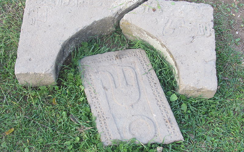
- A hystorical garveyard near Alherd.
-

- Aqdash summer camp.

-

- Babak Fort, near Kaleybar

-

- Kaleybar is becoming the unofficial capital of Arasbaran.

-

- Sheikh-shahab tomb, Ahar, Iran

-

- A holy mountain near Garmanab

-

- A historical landmark in Aynaloo

-

- The aggressive shepherd dogs of Arasbaran are resting in Chaparli.


